The HAZADR high-frequency radar infrastructure system - Channel of Vis, Croatian middle Adriatic
 High-frequency (HF) oceanographic radars are remote sensing instruments that measure surface currents in an area. The radars can measure currents over a large region of the coastal ocean, from a few kilometres offshore up to 200 km, and are the only sensors that can measure currents over a large area of the ocean. The scattered radar electromagnetic waves emitted to all directions over the sea coherently return, resulting in a strong peak of energy at a very precise wavelength, known as Bragg scattering frequency.
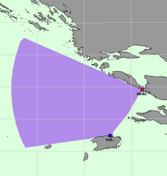
A pair of HF radars have been installed in the middle Adriatic within the frame of the HAZADR project, at Cape Ražanj, island of Brač (43.319688º N; 16.408743º E), and Cape Stončica, island of Vis (43.072141º N; 16.254157ºE). The HF radars were of WERA type, manufactured by Helzel GmbH (http://www.helzel.com), operating on 26.200-26.350 MHz frequency and covering the area of about 50x50 km with spatial resolution set to 1.5 km (Fig. 1). The installation was carried out during early months of 2014, when the Institute of Oceanography and Fisheries (IOF) team did the installation of the equipment at both sites (Fig. 2), with the help of research vessel Bios Dva.
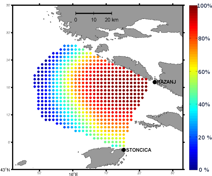
The HF radars have been working almost continuously till today, except for a few months in early 2015, when the storm of the decade broke the installation at the coast, pulling multi-tonnes boulders along the beach and HF radar installations. However, the repair of the equipment were done quickly as the IOF team was quite skilled and trained for such kind of hazards. The spatial coverage of the data availability for the first year of measurements is displayed in Fig. 3, while Fig. 4 presents a snapshot to the measurements in the area.
The WERA HF radars are also measuring ocean surface waves and direction of the wind, all of them available for the area of Vis Channel, middle Croatian Adriatic (http://jadran.izor.hr/hazadr/geoserver_en2.html).
The radar system is operated from the operational centre located at the IOF, where the HF radar data is being acquired, processed and archived. The acquisition of the data is working in real-time through GPRS connection, every 30 minutes, followed by automatic quality check and processing of the data to get surface current fields, which are visualized at the HAZADR website. The data have been stored in the MEDAS database of the Institute of Oceanography and Fisheries, available for a variety of users, including research analyses and operational purposes as demanded from the disaster managing services and others.
The acquired data is a necessary compound of the NEURAL project (www.izor.hr/neural), which has an aim of creating operational forecasting surface current forecast based on measurements of HF radar data, forecasts of surface winds by the operational weather prediction mesoscale model, altogether processed by a kind of neural networks, Self-Organizing Maps. The NEURAL project, executed in parallel with HAZADR project, provides an innovative use of HF radar data and ends with an operative product which may be of help for decision makers and hazard mitigation agencies for a number of applications, like safety of navigation, rescue missions at sea, oil spill tracking and modelling, verification of ocean numerical models, etc.
In particular, HF radar data have been found useful for tuning numerical ocean models to obtain better performance and reliability. Ocean numerical models are essential in assessment of any dynamical phenomena in the ocean, therefore serving as a crucial ingredient to the operational oceanography services. Moreover, the dynamics is an essential component for investigations of biogeochemical properties and processes in the ocean and for that reason, the importance of HF radar measurements are being raised in a number of applications and investigations relevant to the ocean and ocean issues.