About NASCUM project
NASCUM project, initiated in the framework of the INTERREG IIIA Adriatic Cross Border Program (2007-2008), has the major objective to conduct the measurements of sea surface currents in shallow northern Adriatic by using a network of high frequency (HF) radars. Project is a collaborative effort of three Italian organizations and two Croatian institutes: Institute of Oceanography and Fisheries at Split being the coordinator, and also including Institut Ruđer Boković - Centre for Marine Research at Rovinj. Duration of the NASCUM project is 11 months.
The area of the North Adriatic basin is a prone to the heavy traffic, being impacted by a number of possible pollution sources, such as:
- Intense surface maritime traffic, creating immense port and industrial pressure, which together represent a constant danger of pollution;
- Sea contamination due to accidental spillage caused by tanker and cargo ship navigation, both moving along the coast and moored in a harbour.
Major urbanization and industrialization of the coastal area may have a negative influence to the northern Adriatic ecosystem, causing severe economic damage in various sectors such as the fishing industry and the entire tourist industry on a national level, with instantaneous effects and usually irreversible consequences.
Therefore, a hydro-geological risk of such load to the fragile ocean environment is recognized as a threat, with a possibility to assess a hazard and risks through the study of the erosive and depository processes and coastal marine circulation, with the aim of protecting the environmental heritage and promoting sustainable development.
Main objectives of the Project are:
- Characterization of the surface circulation of the North Adriatic, and in some sub-regional zones considered to be at high risk of erosion or pollution;
- Production of vector maps of surface marine currents on which to define intervention procedures for limiting damage caused by environmental accidents due to oil spills; and
- Continuous monitoring of the circulation of the northern Adriatic as a tool for maritime rescue operations.
These objectives can be achieved by measurements of sea surface currents by HF radars and comparison of data with existing measuring systems in entire marine region (oceanographic buoys, coastal stations, autonomous current-meters, drifters, research cruises, remote sensing, etc). Moreover, measurements by HF radar represent the unique method of continuous monitoring of sea surface currents, operative in real time and in all meteorological conditions.
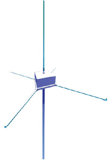
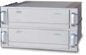
Measuring system in NASCUM project consists of four coastal stations (two of them are located at the west coast of Istra (lighthouses Zub and Savudrija) and two in Italy (lighthouses Bibione and Punta Sabbioni). HF radars analyse the respective radial components of the reflected signals and, by combining their radial components, produce vector maps (intensity and direction) of the currents. Final product of such process is hourly map of the surface currents (here stands for the average of the currents in the first 50-100 cm of water). These maps are normally produced hourly, but they can be produced every half hour on demand. The measurements are carried out using 25 MHz radars covering area of approximately 40*40 km (about 1300 km2) with spatial resolution of 2 km. Measured data has been transmitted in real time through mobile network VIP net Office box to receiving centre in Institute of Oceanography and Fisheries, Split. These data have been validated, processed, stored in database at the centre, and routinely presented in graphic forms at the project web pages.
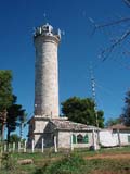
Savudrija
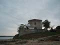
Rt Zub