The main objective of the MESSI project is to build a reliable prototype of a meteotsunami warning system, using knowledge acquired from analysis of historical destructive events, whilst based on real-time measurements, operational atmosphere and ocean modelling and real time decision-making process. The proposed objective will be achieved through 9 modular tasks. These are:
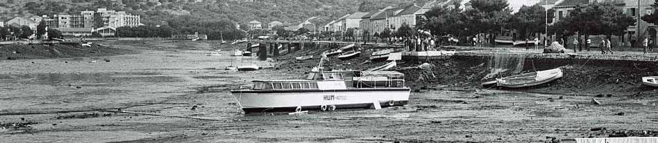
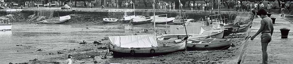
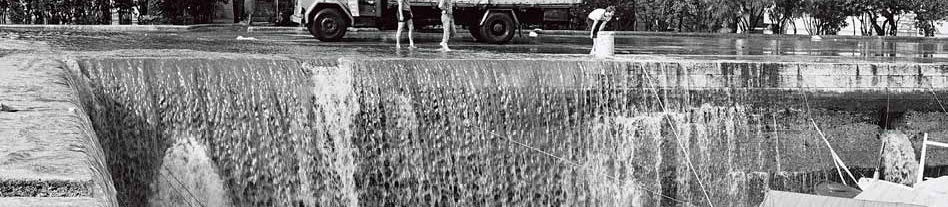
The most prominent and devastating historical Adriatic meteotsunamis (the Ist meteotsunami of 22 August 2007, Mali Lošinj meteotsunami of 15 August 2008, and the middle Adriatic meteotsunami of 24-25 June 2014) will be investigated using available atmospheric data and tide-gauge records both from Croatian and Italian Adriatic coast. Historical events will be reproduced with state-of-the art numerical ocean (ROMS, SELFE-SCHISM, IOS meteotsunami model) and weather (Aladin/HR resolution 1-8 km, WRF-ARF) models. Atmospheric waves are more common than meteotsunami since only rare events generate a meteotsunami. The ability of the meteorological models to generate the atmospheric waves should be verified. Applicability of different numerical models will be assessed, and models will be fine-tuned with respect to the in situ and remote (satellite) observations.
Milestone 1. Historical meteotsunamis revaluated and reproduced (month 8).
Milestone 2. Numerical models assessed and fine tuned (month 12).
A prototype of meteotsunami monitoring station will be build, requiring non-standard approach and setup. Two station prototypes will be created by the IOF engineers: atmospheric station, and ocean-atmospheric station which will be further equipped with the sea level sensor. The OGS engineers, experienced in different operational oceanography and technological projects, will provide an active support. A special software for storing and sending data and performing rapid detection of meteotsunami favourable conditions will be developed as well.
Milestone 3. Meteotsunami monitoring station prototypes built and ready to use (month 12).
Meteotsunami monitoring stations will be installed at the selected eastern (Vela Luka, Vis, Stari Grad, Palagruža, Šolta, Svetac) and western middle Adriatic locations (Tremiti, Ortona, Vieste). Bottom pressure recorders will be installed at the open sea. Installations of stations at Italian territory will be organized by the project Co-PI. Locations of stations will be chosen to achieve three main goals: (i) obtaining sea level and air pressure measurements at the most endangered locations; (ii) obtaining atmospheric measurements from locations far-removed from the shore, allowing for a timely warning; (iii) tracking sea level and atmospheric pressure parameters along propagation and generation route of a meteotsunami - enabling relevant scientific research publishable in top journals. Real-time communication and data delivery from stations to the central processing station and project database will be established. Automatic algorithms for estimation of atmospheric disturbance speed and direction will be developed and tested. Preliminary analysis of collected data, including preliminary quantification of air pressure and sea level relationship, will be done as well.
Milestone 4. Meteotsunami research and warning network operational (month 15).
Milestone 5. Preliminary analysis of data collected by the network (month 21).
Favourable synoptic conditions for appearance of meteotsunamigenic air pressure disturbances will be determined using ERA-Interim atmospheric reanalysis available through European Centre for Medium-Range Weather Forecast (ECMWF) web portal. Using state-of-the art pattern recognition methods (e.g. neural networks), favourable synoptic conditions will be extracted from past and future climate simulations, and statistics of occurrence of meteotsunamigenic conditions estimated. Using historic tide gauge records occurrence rate of the past Adriatic meteotsunamis will be verified.
Milestone 6. Favourable synoptic conditions determined (month 15).
Milestone 7. Frequency of meteotsunami events in past and future determined from atmospheric reanalysis and climate models (month 21).
Historic meteotsunami data and numerical ocean model outputs will be used to map meteotsunami hazard over the Adriatic coast. Expected sea level rise and estimated statistics of meteotsunami favourable conditions in future climates will be taken into account, and meteotsunami hazard maps for future climate will be created as well. Maps will include spatial distribution of maximum expected sea surface heights and currents. Meteotsunami warning matrices, associated to presence of meteotsunamigenic conditions and to rate of change, dispersiveness, speed and direction of air pressure disturbance will be created for the most endangered areas.
Milestone 8. Maps of present and future meteotsunami hazard created (month 16).
Milestone 9. Meteotsunami warning matrices created for the most endangered areas (month 20).
ALADIN/HR mesoscale numerical model will be run operationally at the Meteorological and Hydrological Service. Automatic procedures for recognition of meteotsunami favourable synoptic conditions will be created. A high-resolution non-hydrostatic research ALADIN will be run operationally. Air pressure and wind fields from the ALADIN/HR(NH) model will be used daily to force high-resolution non-structured ocean numerical model SCHISM or ROMS. Sea levels and currents will be obtained from the ocean model.
Milestone 10. An operational atmospheric and ocean model fields available and automatically analyzed in real time for extraction of meteotsunami favourable conditions (month 18).
A warning system based on real-time air pressure measurements and results of atmospheric and ocean numerical model will be created in close collaboration with the project Co-PI. Procedures and algorithms for determining a level of danger will be developed. All data will be collected at pre-described time intervals by the central processing unit: daily synoptic conditions, daily simulations of coupled ocean-atmospheric model, measured atmospheric and ocean data. A station which detects a possibly dangerous atmospheric disturbance will notify other stations to enter a burst mode during which continuous data acquisition, processing and assessing of a meteotsunami threat will be conducted by the central processing unit.
Milestone 11. A prototype of meteotsunami warning system established (month 20).
Project web pages will be developed at the beginning and updated throughout the project. At its final stage, project web pages will contain real-time data from the warning and research network, relevant outputs of numerical atmospheric and ocean models, meteotsunami warning matrices, and estimates of meteotsunami hazard. The database containing all measurements, and results of numerical simulations will be developed and maintained as well.
Milestone 12. Dynamic web content with meteotsunami danger warning created (month 22).
Dissemination of project results will be directed towards: (i) national government authorities, operational services and civil protection agencies, (ii) local authorities, (iii) international programmes and projects. The first and the second will be realized through meetings throughout the project and through organization of a stakeholder workshop at the end of the project. The third will be done through targeted presentations at annual and general meetings of international scientific programmes and projects. Results will be presented at scientific conferences, and at least three scientific papers will be submitted. We'll give lectures for local community, paying a special attention to lectures for children. Project will also be presented through other science outreach activities (e.g., the Festival of Science), and through different public media. Research topics will be offered to masterss of University of Split for doing their thesis work.
Milestone 13. The information on project results and application possibilities will be systematically disseminated to potential users (months 12-24).
Milestone 14. Stakeholder workshop organized (month 24).